Who can say whether it is an archetype woven into the fabric of ancestral storytelling, or a kind of inherited memory reaching back to a real event lost in the midst of time. But the story of a great flood runs like a current through countless cultures around the world. The Aztecs told of the Fourth Sun, an era brought to an end by a fifty-two-year deluge that wiped out humanity. In Mesopotamia, the Epic of Gilgamesh recounts a tale not unlike that of Noah, echoing the fear of water rising beyond control.
Perhaps these legends grew from real floods—local disasters so immense that they felt like the end of the world. And perhaps some of those were not so different from what happened in 1997 in the United States, when the Red River of the North overflowed its banks in a flood not seen since the 19th century. The water surged through the Red River Valley, reaching cities like Fargo and Grand Forks, North Dakota.
Some 50,000 people were forced to evacuate. Damages were estimated to be 3.5 billion (more than 6.4 billion dollars in today’s dollars). Vowing never to endure such devastation again, the people of the Red River valley began to dream of a solution. That dream took root three decades ago and is now becoming reality—a project that uses the wisdom of nature itself to steer floodwaters away from towns and fields before they can do harm. It is called the Stormwater Diversion Channel, a portion of the Fargo–Moorhead Area Diversion project, an ambitious green infrastructure built from the land’s own earth and reinforced with native vegetation.
Here, we take a closer look at this project, led by ACCIONA, and how it stands as a model for how people and nature can coexist—not in opposition, but in harmony.
One of the few measures available during the 1997 flood was the construction of sandbag walls by thousands of volunteers. This collective effort helped lessen the impact, but it was nowhere near enough. Losses in Grand Forks, North Dakota and East Grand Forks, Minnesota, were estimated at US$3.5 billion. In the aftermath, authorities commissioned a feasibility study to ensure such a disaster would never happen again—especially as eight of the ten worst floods on record had occurred since 1989.
That was when the idea of building a piece of infrastructure on an entirely new scale—unprecedented in the region, where only small diversion works existed—began to take root. Years later in 2009, Fargo, North Dakota and Moorhead, Minnesota would see a new flood of record with the Red River cresting at 40.8 feet, pushing the flood fighting measures to the absolute limit. Over 7 million sandbags were used, and 69 miles of emergency measures were put into place to protect the city of Fargo.
The solution conceived included a 35-kilometer earthen levee, three large river control structures and a 48-kilometer-long diversion channel—built not from concrete, but from the land itself. A massive earthworks operation was planned in cooperation with the United States Army Corps of Engineers west of the metropolitan area that sits along the Red River which marks the boundary between Minnesota and North Dakota. This man-made valley featuring natural embankments on either side, will allow floodwaters from the Red River and its tributaries to flow through without threatening homes or infrastructure.
The scale and ambition of the project required a major mobilization of resources. The total project is US$3.2 billion with the diversion channel construction equal to US$1.5 billion. A consortium of three companies, led by ACCIONA and operating under the name Red River Valley Alliance (RRVA), came together to deliver the initiative. Construction of the channel began in 2022 and is expected to be completed in October 2026.
The final design of the stormwater diversion channel incorporates a network of tributaries and secondary streams, all of which will be redirected during flood events so their water enters the channel. Given its length, the project also required extensive integration with the region’s infrastructure: a large number of bridges and crossings were included to avoid cutting off local communities. Interstate highways, rail lines, and secondary roads all intersect the channel, the bed of which will collect overflow during major storms. In total, nineteen road and rail crossings and a major drainage connection form part of the new system.
The term "green infrastructure" applies here in both the metaphorical and literal sense. The stormwater diversion channel will be environmentally green: built using natural materials like excavated soil, avoiding the emissions associated with concrete, and blending into the landscape as if it were a natural feature. Heated aqueducts will even allow fish to pass along the rivers safely during the region’s bitter winters.
And it will be visually green too. Come springtime, native grasses and plants will turn the channel’s side slopes lush and verdant, framing the stream of water as it flows gently along the valley floor. Most importantly, the project will strengthen the region’s resilience in the face of climate extremes. More than 260,000 people are set to benefit from this bold and sustainable initiative.
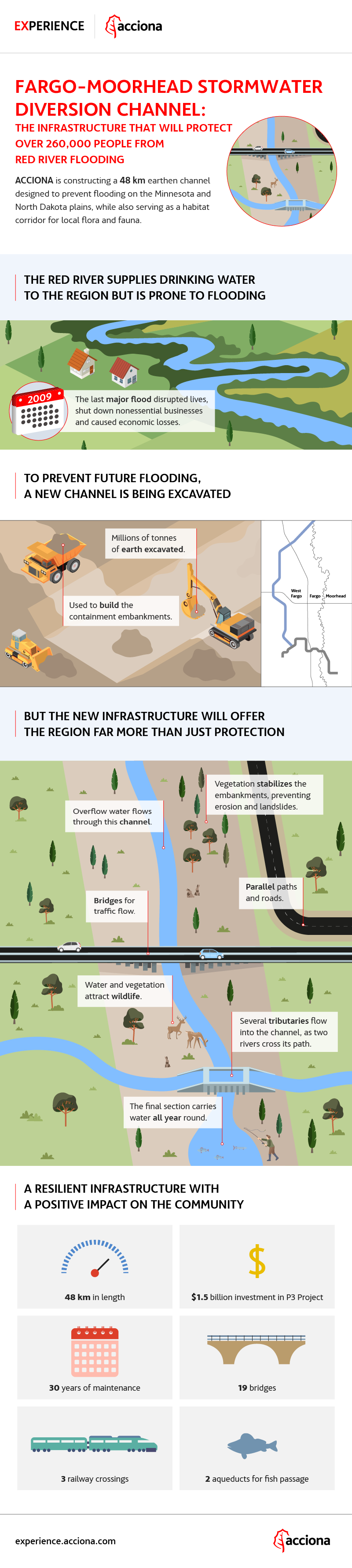
INFOGRAPHIC. How the Fargo–Moorhead channel integrates into the landscape.
A key feature of the stormwater diversion channel is the restoration of native foliage and scrub within the channel and on the adjacent embankments. This vegetation serves a dual purpose: its roots help stabilize the earthen embankments, while its presence also offers natural resistance to the force of floodwaters.
The combination of greenery and water has already become a magnet for local wildlife—birds, deer, and other species have started to make the area their home. At the channel’s outlet, where water is generally present in the channel year-round, it is not uncommon to spot fish, amphibians, and even the occasional recreational angler.
And those anglers will not be the only visitors. Once the project is complete, the channel will serve as a recreation area with a trail on either side of the channel running the complete length of the channel.
This once flood-prone zone will be transformed into a vibrant gathering place for the public. From the very beginning, the project was conceived not just as a protective measure against natural disasters, but as a lasting resource for the public good.
Alongside the construction of the channel, Red River Valley Alliance will also be responsible for operating and maintaining the channel over the next thirty years. But its legacy is expected to stretch much further—as the vegetation takes hold and what began as infrastructure slowly becomes a part of the landscape.
And perhaps one day, when the epic construction of the Fargo–Moorhead Area Diversion project is just a memory, the devastating floods that once defined the region will be spoken of as little more than legend. Stories passed down from parents to children on their walks along the banks of a green channel—a project that marked the beginning of a new era in resilient infrastructure, built to meet the challenges of a changing world.